 Not so long ago, I wrote about a year-long project (2 Truths & a Lie) that I will be collaborating on with a teacher from Texas. In short, we are working with States as it is a 5th-grade standard. Students will be researching and recording information on a shared Google My Map.
This got me thinking. First of all, anyone who knows me knows that I LOVE using Google My Maps in the classroom. This lesson design can be used with other grades and topics.

I believe that 2nd-grade studies habitats. Why not draw a polygon around the regions students will be studying and have them create their own 2 truths and a lie on a shared map? Or in 4th-grade for the California Missions, using the draw line tool, draw the Mission Trail and have them create place markers with the information for each Mission. Again, using the draw a line tool, older students can draw the route of armies for the Battles of Lexington and Concord. Or routes and pin markers can be placed on maps to show battles during the Civil War. A class that studies ecology can log information on a map. In ELA, while reading a story, plot points that correspond with locations and practice comprehension using 2 truths and a lie.
I guess what I’m trying to say is that the possibilities are endless with this lesson design. It makes students dig a bit deeper and think about what they read and think. They have to be ready to analyze the information given in order to find the lie.
So what sort of lessons will you do with your students using 2 Truths and a Lie?


 Google My Maps is found in your
  Last week I had the privilege of being a part of the #cuerockstar #rOxnard faculty. And what an amazing group they were! As tradition, we all had one minute to ‘sing for our supper’ also known as ‘Shred Session’. Yeah, that one-minute time limit? It meant nothing to me! In true RockStar fashion, I went a tad over. In all fairness, Mike Vollmert warned me that my time would soon be up. My response? “I don’t care,” and kept going. That was the first time I ever did that.
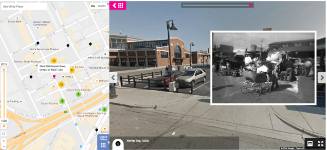
 trivia and location skills. Players are given a trivia question, which correlates to a place in the world, that they then must place Peg Man on the map. This game was developed by Google. The closer you are to the location, and faster you are, the more ‘miles’ you earn. You are given 1000 miles to start the game. However, if you are not accurate you lose ‘miles’. So if your answer is 149 miles away, that’s how many ‘miles’ or points you lose. Once you are out of ‘miles’ the games ends.
 This is a super fun, highly addictive game (if you’re a nerd like me!). There are 2 modes and several GeoGuessr Maps to choose from. When you arrive on the site, the first game is ‘Explore the World’. Using Google Maps Street View, you are dropped in a location. Using clues (signs, vegetation, cars, etc.) you need to place a pin on the map as to the location of where you are. Scrolling a bit further down on the page, there are several maps focusing on countries, cities, and continents. I clicked on ‘North America’ where game maps for Canada and United States, along with some cities, appeared. You can set a timer for minutes and seconds. I mentioned a second mode: Challenge. This is where you can challenge a friend.